
Urban Area Boundary and Functional Classification Update Process
Background
On a decennial basis (every 10 years) following every Census, FDOT leads the process to coordinates a review of the U.S. Census defined Urban Area Boundaries and the Federal Functional Classification of the Florida’s roadways. This review process is conducted by FDOT Districts in cooperation with local partners and concludes with official signed maps that provides information of the agreed upon adjustments (aka “Smoothing”) of an Urban Area Boundary and an update of Federal Functional Classification of roadways in each county. The Urban Area review process incorporates information of the land use conditions and long-range plans to determine what geographic areas are considered ‘Urban’. Adjustments are made to the Urban Area for consistency in the transportation planning and project programming process. The review of a roadway’s Functional Classification coincides with the Urban Area adjustment process to efficiently determine the federal-aid eligibility of a roadway. To ensure the adjustments are made uniformly across the state, the FDOT’s Transportation Data and Analytics (TDA) Office manages the adjustment process by establishing the data standards, reviewing the data, and coordinating the approvals with FHWA Division. TDA is responsible for reconciling statewide data into the Roadway Characteristics Inventory (RCI) for consistency of reporting to the Highway Performance Monitoring System.
Functional Classification Interim Update Process:
As new roads are built, a functional classification of a roadway may be reviewed and updated as needed through a cooperative process between the FDOT, local partners, and approval by FHWA. For more information on this process, users should reference the FDOT’s Urban Area Boundary and Functional Classification Handbook.
Maps and Data:
Users can download the official, signed adjusted Urban Area Boundaries and updated Federal Functional Classification maps from the File Transfer Protocol Site. Maps are available in .PDF format. Users can also access historical Urban Area maps as a reference.
Link to Maps on our FTP site: Cerberus Web Client
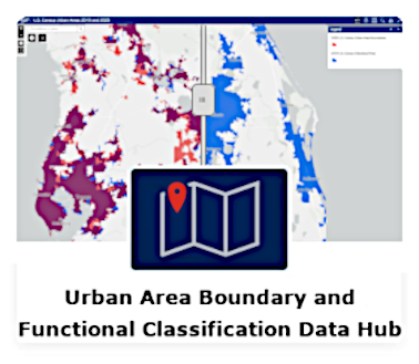
For GIS data, users can access the ArcGIS Data Hub or the FDOT Open Data hub to access the GIS Feature Services of the adjusted Urban Area Boundaries and most up-to-date data and locations of Functional Classified Roadways.
(Urban Area Feature Service Link to Open Data Hub): FDOT FHWA Smoothed Urban Boundaries TDA | FDOT Open Data Hub
(Functional Classification Feature Service Link to Open Data Hub): Functional Classification TDA | FDOT Open Data Hub
Resource Information

- FDOT Urban Area Boundary and Functional Classification Handbook (PDF 1.76 MB) August 2023
- FDOT Urban Area Boundary and Functional Classification Procedure (PDF 283 KB) May 2023
- 2023 FHWA Edition - Highway Functional Classification Concepts, Criteria and Procedures
- 2020 UABFC Info Fact Sheet (PDF 7.1 MB)
- Metropolitan Planning Program Staff (District MPO Liaisons) (PDF 238 KB)
- District Urban Area Boundary and Functional Classification Webinar (PDF 7.9 MB, PPT 16.6 MB, YouTube)
Timeline of the 2020 Urban Area and Functional Classification Update Process
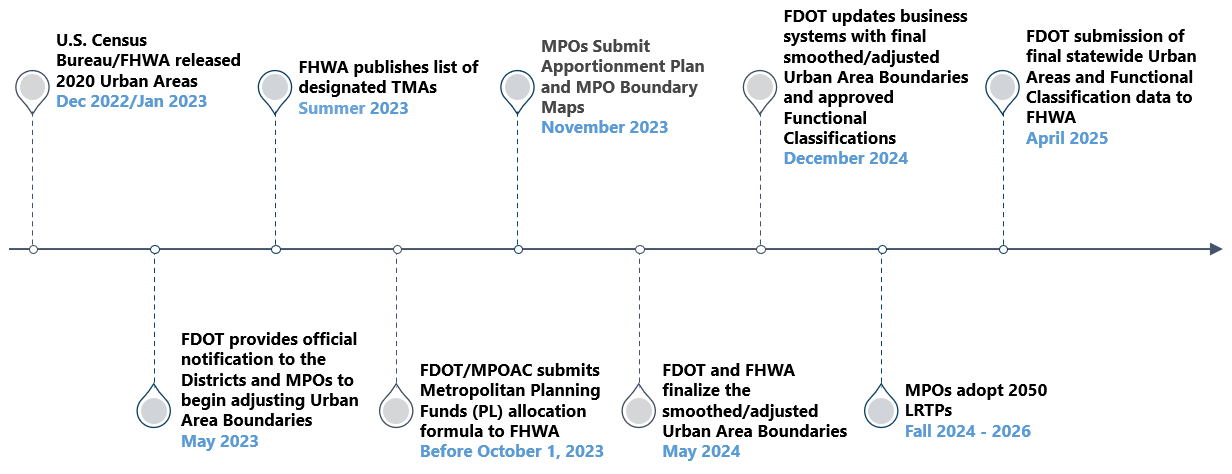
Timeline of the 2020 Adjustment Process
A year following each U.S. Census, the bureau releases a new list of Urban Areas for each state. FDOT receives a list of the qualifying Urban Areas and initiates the collaborative process to review and adjust the Urban Area boundaries and Federal Functional Classification of roadways. FDOT is required to perform this review within two years of the release of the Urban Areas and submit the data to FHWA. The 2020 timeline listed below provides a set of milestones user must consider in the comprehensive transportation planning process.
Contacts
For update process inquires, please reach out to our Statewide Coordinators:
District 1 Counties: Charlotte, Collier, DeSoto, Glades, Hardee, Hendry, Highlands, Lee, Manatee, Okeechobee, Polk, Sarasota | District 2 Counties: Alachua, Baker, Bradford, Clay, Columbia, Dixie, Duval, Gilchrist, Hamilton, Lafayette, Levy, Madison, Nassau, Putnam, St. Johns, Suwannee, Taylor, Union |
District 3 Counties: Bay, Calhoun, Escambia, Franklin, Gadsden, Gulf, Holmes, Jackson, Leon, Liberty, Okaloosa, Santa Rosa, Wakulla, Walton, Washington | District 4 Counties Broward, Indian River, Martin, Palm Beach, St. Lucie |
District 5 Counties: Brevard, Flagler, Lake, Marion, Orange, Osceola, Seminole, Sumter, Volusia | District 6 Counties: Miami-Dade, Monroe |
District 7 Counties: Citrus, Hernando, Hillsborough, Pasco, Pinellas | Turnpike Counties: Brevard, Broward, Citrus, Clay, Duval, Hernando, Hillsborough, Indian River, Lake, Martin, Miami-Dade, Okeechobee, Orange, Osceola, Palm Beach, Pasco, Polk, St. Lucie, Sumter |