
Divisions
| Geographic Information Systems Geographic Information Systems (GIS) is a standard tool commonly used by the Florida Department of Transportation to support transportation decision making. This office supports an organization-wide framework for the governance of GIS technology that will facilitate effective management, communication and collaboration of shared geospatial data and resources. |
| The Surveying and Mapping Office leads statewide surveying and mapping efforts through spatial technology expertise in support of Florida's transportation system. This office supports surveying and mapping activities statewide by providing policies, procedures, guidelines, and training. |
| Transportation Data and Analytics The Transportation Data and Analytics (TDA) Office is the FDOT's central clearinghouse and principal source for highway, traffic, travel time, multimodal, and freight and passenger data information. We provide the data and information that supports the mission of the FDOT to ensure mobility for people and goods |
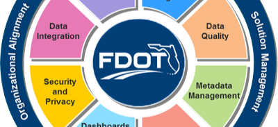 | Data Governance
The Data Governance section is responsible for providing information about data governance and ensuring FDOT's data governance policies and data initiatives are followed. |


Questions? Please use the following online form to submit a question to a member of our team: Contact Us